JOGINDERNAGAR-‘ Electric City’ or ‘The City of Powerhouses’
HISTORY: In 1925, the enterprising Raja Joginder Sen of Mandi created an elaborate hydel power scheme near the village of Sukrahatti which was then renamed Joginder Nagar (1220m) after him. After tunneling and piping the water over several kilometers from the river Uhl to Joginder Nagar, the Shanan power house was built by a team of engineers headed by Col. Batty. Later, the HP State Electricity Board added another set of turbines at nearby Bassi.
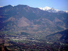
Joginder Nagar has everything for a quite and relaxing holiday and leaves options open for trekking, fishing, sightseeing, picnics and enjoyable drives in the area.
ACCESS: Joginder Nagar is the terminus of the narrow gauge rail track from Pathankot. The narrow gauge train leaves at 9.50 am from Pathankot. It is 65 km by road from Kangra an 55 km for Mandi. The nearest airports are at Gaggal (Kangra), and from the one at Bhunter near Kullu the distance is 115 km. Taxis and buses to Joginder Nagar are available at all major stations.
CLIMATE: In winter the temperature can hover just above freezing point when heavy woolens are required. During summer, the climate is mild and light woolens / cottons are recommended.
Details of Temperature are as follows:-
Coldest Month- January or February (Min. Temperature upto -2˚ C)
(Mercury dips down upto -10˚C at nearby mountains)
Hottest Month- May or June (Max. Temperature upto 34˚ C)
Rainiest Month- July or August (more than 60% average rainfall in these months)
Average snowfall at nearby peaks- 200 cm
Annual Average Temperature- 20˚C
* Jogindernagar is one of the rainiest places of the state. Tons of rain in monsoon season and reasonable rainfall throughout the year.
Season Details:-
Season Timings Average Temperature Range
Spring - Mid February to late March 12˚ C to 20˚C
Summer - Mid April to late June 16˚ C to 28˚C
Rainy - Late June to late September 18˚ C to 26˚C
Autumn - October to late November 16˚ C to 24˚C
Winter - Late November to mid March 08˚ C to 14˚C
TOPOGRAPHY, FLORA & FAUNA:
Jogindernagar lies in between lower Himalaya and Mid Himalaya. The altitude of Jogindernagar ranges between 900 m to 2800 m. The altitude of the city is 1220 m. The weather and climate remains cool in Winter and mild and warm in summer season. JOGINDERNAGAR lies between two small Himalayan Ranges. In the North-East of city beyond Winch Camp Range lies Nargu Wild Life Sanctuary home to the ghoral, Himalayan black bear, leopard, Monal, kite, eagle, snakes, monkey, kasturi deer, wild cat, nilgai, kakkar and a variety of pheasants covering a total area of 278 sq. kilometers. The sanctuary is the home to various varieties of wild animals, pheasants, lizards and birds. Most of the area of Jogindernagar is covered with forests, trees and locally grown crops. The nature of water is hard because of coming from high altitude peaks.
THE UHL: At Joginder Nagar, Himachal tourism runs the Hotel Uhl named after the river whose water have been channeled to the power house. It's large twin structure is built of finely dressed stone, and has a sprawling lawn with frontage along the highway. While the hill rises behind it, the hotel has a view of the valley below Joginder Nagar.
ADDRESS: Hotel Uhl, Joginder Nagar (H.P.) - 176120
Tel: (01908) - 222002
CLASS: Deluxe Hotel.
Check availability and book the Uhl
- Rooms are airy, specious with wall to wall carpeting, attached well appointed baths with running hot & cold water.
- Restaurant, Rooms Service, Satellite Television, Laundry and Dry cleaning arranged.
Parking within premises. Jogindernagar has also other deluxe and well standardized hotels, cafes and restaurants.
MORE ABOUT JOGINDER NAGAR
The town came into prominence in 1932 when the first hydroelectric project was constructed here. It was the only hydroelectric project in northern India which fed undivided Punjab and Delhi.
The economy of the town got a fillip in 1970 when the Bassi power house was built utilizing the tail water of the Shanan power house. The generation cost at this project is the cheapest in the country.
Soon after the completion of the project the business received a setback with the migration of thousands of workers engaged in the construction.
Jogindernagar is one of the few towns of Himachal Pradesh connected by rail. Jogindernagar is well connected with road and railway line. Once it was the biggest potato market of northern India. At that time the potato growing valleys were not linked by roads. Over 2,000 mules from the Lahaul and Spiti valleys transported potatoes from far-flung areas to Jogindernagar which was the only railhead in this part of the state. Potatoes from Mandi, Kullu and Lahaul-Spiti districts were brought here for further transportation to West Bengal.
Jogindernagar is the only city in Asia having three power houses simultaneously – Shanan Power House (110MW), Bassi Power House (60 MW) and Uhl Stage III (100MW). These three power houses adds up their potential to 110+60+100=270 Megawatt (MW). One very special thing about it is that these all Power houses is that these are being run by using the water of single river ‘Uhl’, which originates from a high peak of Dhauladhar ranges having altitude 14,500 feet in Kangra district.
Jogindernagar has now countless institutions, colleges, schools, clinics, hospital and other infrastructures. It has a beautiful herbal garden along with Ayurvedic Research Institute growing hundred of verities of herbs, trees, flowers, fruits and vegetables. Herbs are primarily used for making Ayurvedic medicines for curing certain diseases. Students from distant places of the state come to gain knowledge about herbs.
PLACES OF INTEREST
Haulage Way System (4km) Here is a haulage way system in Jogindernagar which is perhaps its only kind of track in the world. There are different haulage way stations in this particular transportation system starting from Buffer stop 1290m (4150 feet). Next is Adit Junction set at an altitude of 1825m (6000) feet is locally called as 18 number as it is imprinted over there. The water rushes down from the reservoir at Barot in the Uhl river through penstock pipes going down nearly a thousand meters (3280 feet). The loading capacity of haulage way cars are 15, 10, 5 tons. Higher the capacity, lower the speed.
Winch Camp(7km) The next and much adventurous is Winch Camp situated at an altitude of 2400m (8000 feet). The height of the peak is near about 8800 feet. Trekking to winch camp from Jogindernagar takes 3 hours at least and 1 and half by Haulage way car. On the way to Winch camp there are thick forests of Rhododendron (Burans or locally known as Brah ka fool) from which people prepare delicious sauce having a great medicinal use. From this place one is able to see kilometers of distance including Beas River, Mandi Hills, Kangra district and Hamirpur boundaries etc. Over these high altitude mountains one can feel the pleasure like Heaven. In winter season there is heavy snowfall over these mountains which sometimes even scales up to 4 feet or above. At this time local people, tourists, students from schools and colleges step onto these marvelous mountains for having the gorgeous pleasure of snowfall on their feet. On the other side of the mountain is Headgear, the next haulage way station at an altitude of 2500m (8300 feet). This spot packs outstanding sceneries of Himalayan ranges including Dhauladhar which are about 15000 feet or above from the sea level. From Headgear haulage way car descends down the steep hill having a large gradient. This steep hill is known as ‘Khooni Ghati’ means ‘Valley of death’ as it is locally said that there had been any accident over here but nobody is sure in this regard. Further coming station is Katheru set up at an altitude of 2150m (7000) feet above sea level. The next short journey track is called as Zero Point at 1890m (6050 feet).
Barot(13 km by trekking, 41 km by Bus) Afterwards a short on foot journey of 2 kilometers ends at a panoramic picnic and tourist spot called Barot, 41 km by road from Joginder Nagar, and 13 km by the Haulage trolley at an altitude of 1810m (5940 feet) . This is the most beautiful hill station of Jogindernagar packs an enormous range of outdoor activities. Two reservoirs of the power project is located here. A trout breeding centre makes it a wonderful place for angling. Across the river Uhl is the Nargu Wild Life Sanctuary home to the ghoral, Himalayan black bear, leopard, Monal, kite, monkey, kasturi deer, wild cat, nilgai, kakkar and a variety of pheasants. Every year hundreds of tourists from nearby places and states like Punjab, Haryana visit it. In winters snowfall takes place here and makes its beauty much gorgeous. There is also a high altitude panoramic lake at an height of 4280m (14050feet) known as Danasur lake where holy journeys are started in the month of August and September. Lord Hanuman is believed to have stopped over this place while killing an evil witch. There are many varieties of herbs and flowers over these mountains having great importance and medicinal use. There are many beautiful temples of local Devtas (Gods) in this valley known as Chauhar Valley. Proper arrangements of staying are available in rest houses being run by govt. and hotels being run by local bodies within reasonable and cheap prices. One Govt. school, computer and music centre as well is located here. Population of Barot is a thousand approximately.
*Literacy rate in Jogindernagar is round about 80% which is much more than literacy rate of India and Himachal Pradesh according to Population survey of 2001.
Bir-Billing (16km) - Paragliding Pre-World Cup Spot
Paragliding Pre-World Cup is held every year at Bir-Billing (16 km from Jogindernagar) in the month of October or November. Billing 2650m (8600 feet) is the hang gliding spot from where Para gliders take off for landing at Chaugan, where this competition is held. According to paragliding specialists this is the finest spot for paragliding in the world. Ever year hundreds of participants from all over the world take part in this particular competition. Thousands of tourist and viewers from distant places come to join this Cup. Billing is well connected with road where competitors land off to win this great Cup. They fly over the mountains of Baijnath and Jogindernagar for selected distance. This Cup is started by Hon’ able Chief Minister of the State. Some important world records have been made by foreigner Para gliders here. They signify it as ‘Heaven for Paragliding.’
Unfortunately due to defective govt. plans and some political reasons the cup has been renamed ‘Himalayan Cup’ and this competition couldn’t be held in the year of 2007.
Shanan Power House (3km)
Jogindernagar is the only city in Asia continent having three Power houses simultaneously. The vision of the hydel project scheme was to construct 5 power stations using the same water that is drawn from the Uhl River. Shanan Power House of Jogindernagar is the oldest Hydro-electric power house of India and one of the oldest powerhouses of the world. This power house was built by Col. Batty, an English engineer and his team. Most of the credit of creation of Jogindernagar and to make it a popular town goes to him. Afterwards more high capacity turbines were built here but unfortunately, being this power house in HP it is still under Punjab State Govt. HP Govt. is still not paying their attention towards this matter.
Railway Track (0km)
Jogindernagar is well connected with a narrow gauge railway line. Rail Head of one of the world's still playing narrow Gauge train. This railway track is one of the oldest in India and was built in 3rd decade of 20th century when Shanan Power House was to be constructed. There was a steam engine which has been replaced by diesel engine. Jogindernagar-Pathankot is the longest railway line track of Himachal Pradesh.
Baba Balakrupi Temple (2km) This beautiful temple is situated in Balakrupi village which was renamed after this temple. An annual fair is held here at nearby temple ground at every Saturday of a particular month.. It also packs a beautiful picnic spot called as Thara which seems like a small plateau. On the right hand side of this place is Gugli Khadd where people enjoy swimming. Balakrupi is 2 km from Jogindernagar. In Balakrupi temple a special tradition of cutting down the hair of 2 and half year old child known as ‘Mundan Sanskar’is done.
Jhalwan (2km) This beautiful village is situated beside state highway 20.It has only Govt. revenue training centre of the state near Jhalwan (3km from Jogindernagar). At nearby Bhatta a beautiful residential colony for Uhl Stage III employees is situated. The temple of Chamunda Mata, the Goddess of war is situated here. Devotees from distant villages come here. Here one temple of Lord Shiva is situated at Bagh. The residential colony near Bhatta is made in modern style and gives a view like a city.
Lakshminarayana Temple (5km) In a nearby village known as Ner (6km from Jogindernagar) is a hundreds of year old temple of Lord Lakshminarayana. Lord Vishnu is said to have meditated here for 300 years and is built by Pandavas. This temple came into the minds of people when an industrialist from another state dreamt God and God said him to take care of the temple. Industrialist donated thousand of rupees for the repair of this temple. It is said that the idol of God on that night moved inches from its original place and bells started ringing automatically. The temple is of great importance but unfortunately this has not been reasonably recognized by the govt.
*In every village of Jogindernagar there is a specific temple held sacred to Devta (God or Goddess)of that particular region. It is believed that a particular Devta looks after the whole village. These all villages are strongly connected to their customs and traditions.
Bassi Power House (6km)
The generation cost of Bassi Power Project at Jogindernagar is the cheapest in the country. Its capacity is 60 MW. The powerhouse runs by using the discharged and piped water of Shanan Power House of same river Uhl. The water has been collected on canal built by and by the road which leads to Chaproat where the reservoir of water for Bassi Power House is situated. Water is further piped down to the turbines of water. A haulage way system is also built here but unluckily not working.
Chaprot (8km)
This is an enormous picnic spot situated at an altitude of 1240m (4075 feet) above sea level. On the occasion of Christmas Day people come here to celebrate and enjoy. A beautiful reservoir of Bassi Power House is situated here. A haulage way system was also built here after independence which still not working.
Chauntra (10km)
It’s a beautiful town situated at an altitude of 4,250 feet above sea level. There are many beautiful Buddhist monasteries and a large Institution of Tibetans. This town is also showered with tea orchards. An annual fair is held here at nearby ground.
Banderi Temple (4km) This temple at Banderi peak (5225 feet) is held sacred to Goddess Banderi. People from distant villages come for the completion of their prayers. A big public lunch locally called as Bhandara or Jug is held in Navaratra period. Half a km from this temple is Kila Karanpur Fort made by Raja Joginder Sen.
Banar Baba Temple (12 km) A beautiful temple at an altitude of 1750m (5500 feet) above sea level is held sacred to Banar Baba or Baba Balaknath and situated in Banar village at a steep rocky mountain. It is said that various kind of skin diseases can be cured by taking bathe near a waterfall at Banar village.
Brajeshwari Temple (13km) This temple is popularly called as Garha wali mata Temple situated at an altitude of 1450m (4775 feet) is held sacred to Goddess Brajeshwari. Thousand of people every year come to pray Goddess. Ancient time forts are also there and a small fair is held in Navratra Period. From this place one can see over the areas of Mandi, Kangra and Hamirpur district.
Baijnath Temple (20km) 20 km from Joginder Nagar is this exquisite temple where Lord Shiva is worshipped as Vaidyanath - ‘The Lord of Physicians’. The original temple was built in 804 A.D. Here King Ravana is said to have supplicated Lord Shiva for this boon of immortality.
Machchiyal Lake (6km) 6 km from the Hotel Uhl is this small but enchanting lake held sacred to Machendru Devta means the God of Fish. Fish are fed and worshipped here especially on Saturday and Tuesday. Fishing is strictly prohibited here. A fair in the month of April is held here every year. A beautiful bridge over Gugli Khadd, a small river, is situated here. Out flowing water of Uhl river from Bassi Power house meets into Gugli Khadd. Some beautiful temples of Machendru Devta are lying beside the lake with very old idols of God of Fish.
Chaturbhuja Temple (25km) This is a very ancient temple said to be built by Pandavas is situated at an altitude of 1475m (4830 feet) held sacred to Goddess Chaturbhuja, a form of Goddess Durga, is situated in Basahi Dhar. It’s an enchanting temple along with 100 feet high TV tower. A big fair is held here in Navaratra Period.
Siqandar Dhar and Forts (15km by road, 8km by trekking) Siqandar Dhar is one of the highest peaks of Jogindernagar lying at 6010 feet from sea level and is a small mountain range of 30 km from North-west to South-east. Certain beautiful villages, temples and fort are lying here. Thick rhododendron forests can be found home to various wildlife species.
High Peaks (5-20km)
The highest peaks of Jogindernagar are Billing peak 2850m (9510 feet), Winch Camp 2680m (8825 feet), Jhatingari 2020m (6,725 feet), Siqander Dhar 1830m (6010 feet), Banderi 1590m (5225 feet). However Winch Camp is the nearest (8 km from Jogindernagar). In Siqandar Dhar peak as well as Banderi some ancient forts are constructed by Rajas of that period. There is heavy snowfall over these mountains during winter.
The gorgeous Jogindernagar is simply described as ‘The City of Powerhouses’ or ‘Electric City’.